
by Kripa Krishna
This article traces Bangalore’s history of development particularly diving into the history and political evolution of storm water drains. It identifies commodification of public commons like lake beds, storm water drains, to be a strong cause of Urban flooding. Real estate capital flow in 1991 is traced in interaction with government institutions and public commons. Power politics within the real estate industry plays a major role in targeting the poor to be the victims of floods. The piece ends with emphasizing the importance of relational sensibility of the local areas to achieve an intelligent urban planning process
Urban flooding has witnessed an increase as the climate crisis progresses. While floods are passed off as a natural phenomenon that is not in our control, the way a city is planned majorly influences the level of flooding, the resilience of the city to tolerate the monsoon and who the victims of the flood are.
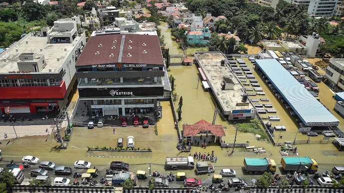
This year, many heavily urbanised cities have experienced a lot of loss due to floods. Bangalore experienced heavy rains in August and September, flooding over 4000 houses overnight, Mumbai, as of July 2022, had at least 104 rain-related deaths, and Hyderabad’s death toll was 50 in the 2020 floods. All these floods are not just a consequence of heavy rain. While climate change does influence the frequency of rainfall, It is not enough to acknowledge climate as the sole reason, the problem is also rooted in the unequal and unintelligent city planning that drastically modified the environment to make way for markets. This article will deep dive into the planning of Bangalore, a city in Karnataka with a population of over 13 million, to lay out the backlogs in urban planning that made the city flood-prone.
The Making of Bangalore
cities are in today. Bangalore has no major river flowing from within, instead, it has four major valleys and an oscillating wetland terrain that is perfectly suited for an irrigation system driven by the storm flows. To domesticate the storm flows that the region received, around 1000 lakes were built which were all interconnected through canals. The logic in making this system was simple: the excess water present in the higher gradient would flow to the lakes in the lower gradient through the canals, forming an interdependent, gravity-fed system. Agricultural communities came up around these wetlands forming a village community. This crucial interdependence of water bodies and the dependence of agriculture on this system was completely destroyed as the wave of urbanisation swept in.
A major change that took place in the maintenance of stormwater drains, i.e canals, was the redefining of their function during the colonial regime (19th century). When the British came in, canals started to lose their significance as a source of irrigation water for the city. The existing canals did not meet the water needs of the British and the industries that they bought in. Hence, they started a capital-intensive water scheme on the Arkavathy River to draw water to the city. This was the beginning of the ‘commodification and urbanisation of water’. Drawing water from the Arkavathy river fueled the industrial set-up in the city while also imposing state power on commons and centralising water resources. This is the same trend Bangalore experiences today where the city draws water from the Cauvery River, 100 km away.
In 1898 when the bubonic plague hit Bangalore, the colonial regime set out a series of projects for the ‘improvement’ of the city. Their definition of dirty was associated with anything non-European and the administration felt compelled to ‘cleanse’ the city. They did so by detailing sewerage networks which were placed in the pathways of the canals in the peaks and dips of the valleys. This recasting of stormwater drains to sanitary water drains is reflected in many post-colonial cities. In the case of Bangalore, since the water was pumped from the river, the irrigation canal was no longer needed. The sewage infrastructure took its place within the stormwater drains causing a huge flood risk to the city. This practice of locating sewage pipes within canals continues to date.
Moving to post-colonial Bangalore, the Bangalore Development Authority, created in 1976, was quite eager to expand the city and build more residential layouts. By the late seventies, farmlands were taken away from communities to accommodate for the homogenous residential layouts BDA had planned throughout the city. These layouts were built without any attention to the local landforms. The nature of the streams was changed to fit sewage pipes within the canals, causing the canals to overflow with eutrophic slushy muck which found its way to the lakes. This nutrient-rich muck provided the perfect breeding ground for mosquitoes leading to a Malaria epidemic in the late 70s. To tackle this, BDA drained out the lakes in an attempt to destroy breeding grounds. There was no effort to clear out the effluents that made their way to the lakes. This suddenly gave rise to a lot of empty lake land that was eventually encroached by housing layout and corporates, building within the wetlands of Bangalore. This trend of converting wetlands into residential or commercial plots is seen in most metropolitan areas in India and is one of the major causes of flooding.
Urban Political Ecology
The field of Urban Political Ecology seeks to understand the complex relations that govern the political, social and economic structures to access the urban environment. In Bangalore, the relational politics surrounding stormwater drains provides deep insight into the urban flood risk. We’ve discussed this context in the colonial regime, however, in the post-colonial city, the relationships are further complicated by the flow of real estate capital.
In the late 90s, when liberalization took place, Bangalore received huge foreign investment in the IT sector. The city’s long-standing engineering expertise, the majorly English-speaking crowd, and pro-reform politicians provided the ideal conditions for MNCs to invest. Power elites secured such investments by providing companies easy access to land, resources and infrastructure. The capital flow was disproportionately concentrated in the southern parts of Bangalore where the city’s high-tech industries and wetlands are accumulated. Private players and parastatal authorities like the Bangalore Development Authority (BDA) and the Karnataka Industrial Areas Development Board (KIADB) have been complicit in developing real estate, skyrocketing land values and easing market practices, while destroying the wetlands and grazing pastures in the process. This was facilitated often through land grabs, illicit environmental clearances, and informal arrangements. The entire IT/BT corridor that got dangerously flooded this September is located on the pathways of the water flow (canals and wetlands). These urban infrastructures have encroached on wetlands where the water would have otherwise been stored. To enable such environmental violations, the government regularized many encroachments by the MNCs paying no regard to the consequences. Such illicit land politics behind urban planning is a major determinant of the flood risk in the city.
Furthermore, encroachments are not confined to MNCs. Many residents who live on lake beds are not even aware of it. Since the wetlands are filled only during the monsoons, dry, empty canals and tanks during the summer are capitalised. Developers level the canals and tanks making them a tangible property that they can sell off to buyers. During the Malaria Epidemic, when lakes were emptied, this opportunity was widely utilized. As a consequence, a golf course sits on the Challaghatta tank, a cricket stadium on Sampangi Tank and a city bus station on the Dharmabuddhi tank. This pattern follows across Bangalore where canals, tanks, wetlands and other public commons have been encroached on and commercialized.
Victims of the floods
The impacts of the floods are disproportionately more on the poor neighbourhoods. When there is no place made for the poor in the city plan, the high land prices drive the poor to occupy empty land next to lakes or on lake beds. The concretization of the city and its water networks magnify the flooding and its effects are felt the most by the poor. Makeshift housing or weak concrete is destroyed by one flood. The poor lose everything, from their house to their livelihoods as they are unable to attend work during the floods. Further, with little to no assets remaining it is unlikely that they can take a loan or borrow money and they are left to fend for themselves. This brunt is also borne by the religious and caste minorities. The city is built on the foundations of discrimination, made to cater to the rich and foreign companies. Rich neighbourhoods occupy lake land but escape the consequences of flooding whereas the poor neighbourhoods suffer and are labeled encroachers (For more information, see Ranganathan, 2021).
This non-inclusive planning of the city is not new. The amendments proposed in EIA 2006 removed apartments and residential complexes from the purview of public consultation. The provision detailed that any project occupying less than 20,000 sq ft did not need public approval. This push towards urban infrastructure largely benefited the real estate industry. The lack of consultation when the city was expanding paved the way for the government and the private players to engulf the smaller villages and towns while disregarding its ecological landforms. This made way for sand mining from the lake, Special Economic Zones, stone mining, granite mining and industrial zones. The amendment limited the power of the public to largely benefit the real estate agencies.
What can be done?
Over the past years, many court orders and laws have addressed the issues mentioned above. In 2012, the Bangalore High court gave an order to de-privatize lakes and rehabilitate the lakes and canals that have been encroached upon (Environment Support Group and ors. Vs. State of Karnataka and ors. (WP 817/2008). The Environment Protection Act has several clauses that demand city planners and developers to take into account all the impacts of urbanization. If these laws are used in their truest spirit, the Air and the Water Act would protect the waters and the toxic substances from entering the water bodies due to rampant urbanization. While the law does protect the environment from these conservative planning measures, the implementation of these laws is lax.
Further, the narrative around environmental governance requires more fine-tuning. For example, while it is acknowledged that encroachment of public commons is undemocratic and destructive, the rehabilitation of these lakes still follows an unscientific methodology which pays no heed to the biodiversity and ecological needs of the wetland. Today we are not equipped with ‘lake-governance’ authorities but ‘lake-development’ authorities. There is a major lack of understanding of the needs of nature and focusing on anthropocentric protection of nature.
The challenge for any urban planning is to ensure that relational sensibility exists when bringing forth development. The plans should be executed not through authoritarian plans codified in expert language but by accounting for multiple forms of knowledge from the local ecology and the livelihoods that strive there.
Kripa Krishna is a 3rd year undergraduate studying Political Science and Environmental science at Ashoka University, Sonipat. Her research interests lie in environmental politics and environmental justice
Image source:https://www.indiatoday.in/news-analysis/story/decoding-the-causes-behind-bengaluru-flooding-woes-1997488-2022-09-07
